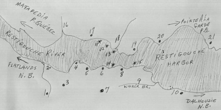
AND THE LITTLE COMMUNITIES WHICH LINED ITS BANKS BACK THEN
Heck ! I never professed to be an artist :)
![]()
![]()
The Northside of the Restigouche river is the Province of Quebec
the Southside is New Brunswick
![]()
 1. Christopher Brook
![]()
2. Tide Head
![]()
3. Atholville
![]()
4. Old Church Point
It was here while digging to lay a foundation
That an old Indian Burial ground was found in the 1950's
![]()
5. Ferguson Point, It is here behind the actual Pulp Mill
That "The Old Athol House Cemetary" is located
It consist mainly of graves of Scotish settlers
![]()
6. Pratt Point
![]()
7. Sugarloaf Mountain
![]()
8. Duncan Point or now known as Campbellton
![]()
9. Walker's Brook
![]()
10. Richardsville
![]()
11. Where the ship "Le Bienfaisant" was sunk in 1760
![]()
12. Where the ship "Le Marquis de Malauze was sunk in 1760
![]()
13. Where the ship "Le Machaut" was sunk in 1760
![]()
14. Where the ship "Shcooner" was sunk in 1760
![]()
15. Where the ship "Repulse" was sunk in 1760
![]()
16. Kempt Road (road leading to St Fidele, P.Q.where I was born
![]()
17. Bourdeau Point
![]()
18. Officer's Brook (Where it is stated by some researchers that the
Village "La petite Rochelle" was situated
![]()
19. Mission Point (now Ste Anne de Ristigouche)
![]()
20. Cross Point
![]()